


 Foto: Mickael Tannus Photography AB
Getting here
Söderåsen National Park is 40 kilometers east of Helsingborg in Skåne. The national park is situated on the ridge Söderåsen which stretches from Åstorp in the north west to Röstånga in the south east. There are two entrances: Entré Skäralid and Entré Röstånga.
Entré Skäralid with the naturum Söderåsen visitor centre is in Skäralid, along highway 13, halfway between Röstånga and Ljungbyhed.
Entré Röstånga with a tourist office is in Röstånga.
There are bus stops at both entrances and in several places along the national park border.
We have quite a lot of visitors at the main car park in Skäralid on weekends and during high season (June, July, August). It is also very popular to visit in spring - during the leaf burst and in autumn during the autumn colouring.
Please come early if you want to be sure to have a place to park your car.
Most visitors come for the views and for hiking. If you prefer a calmer nature experience we have some suggestions for alternative nature areas in the national park vicinity which might be of interest.
Please look at "Nearby nature areas" in the menu to the left or follow the link below
Plan your visit
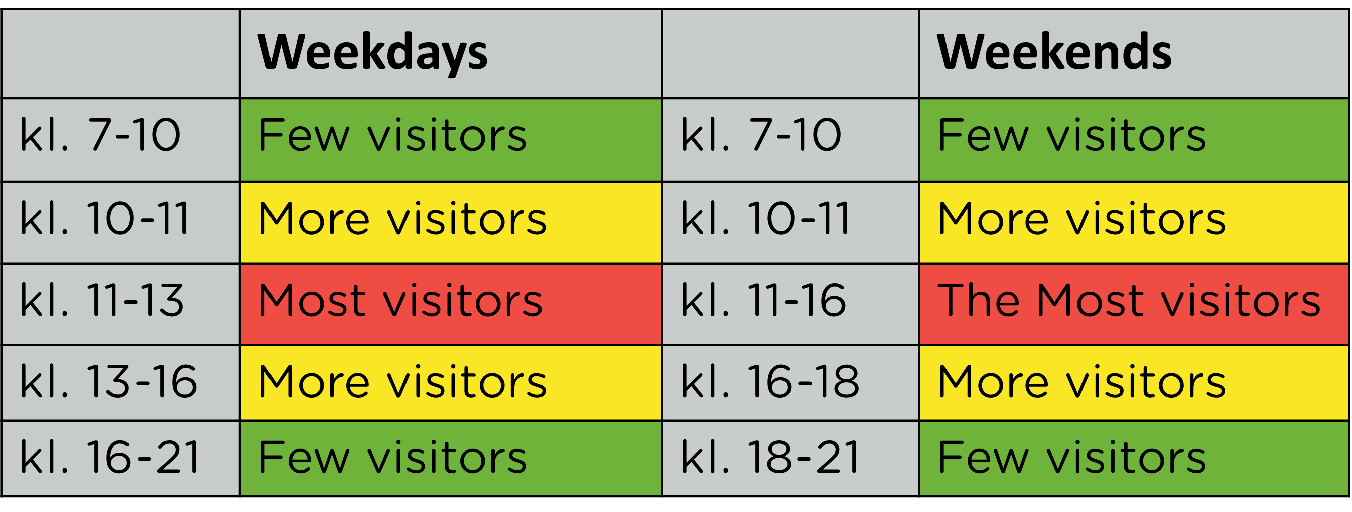
The table below will help you plan your visit regardless of whether you want to visit the national park on a weekday or on a weekend.
Green colour - few visitors
On weekdays until 10 o'clock in the morning and after 4 o'clock in the afternoon.
On weekends until 10 o'clock in the morning and after 6 o'clock in the afternoon.
Yellow colour - more visitors
On weekdays between 10 o'clcock and 11 o'clock in the morning and
between 1 o'clock and 4 o'clock in the afternoon.
On weekends between 10 o'clock and 11 o'clock in the morning and
between 4 o'clock and 6 o'clock in the afternoon.
Red colour - most visitors
On weekdays between 11 and 13 o'clock and
on weekends between 11 and 16 o'clock.
Go to the National Park by bus
On Skånetrafikens website you will have a journey planner and you will find bus and train time tables for travelling to the national park.
You can only pay for your bus ticket with the help of the Skånetrafiken app. In the app you pay for the ticket and then scan the ticket when entering the bus.
Some stations will have a ticket machine - check the app for details.
The bus stop for Entré Skäralid and visitor centre is: Skäralid, nationalparken
The bus stop for Entré Röstånga is: Röstånga busstation (busstn)
There are also other options for embarking/disembarking along the main road.
You have the following stops between Röstånga (in the south) to Skäralid (in the north)
Uggleröd
Härsnäs
Ibsberga
Skäralid - pensionatet
Get directions to the National Park
You can travel to the national park from many directions, below there are suggested routes from Helsingborg and Lund.
- From Helsingborg City to Entré Skäralid, 45 km, 35 mins (Google Maps)
- From Helsingborg City to Entré Röstånga, 50 km, 40 mins (Google Maps)
- From Lund City to Entré Röstånga, 45 km, 45 mins (Google Maps)
You can also use the following coordinates to navigate here...
- For car park at Entré Skäralid: N56 2'22,991" E13 15'9,118"
- For car park at Härsnäs : N56 1'16,927" E13 15'55,557"
- For car park at Entré Röstånga: N56 0'10,857" E13 17'21,078"
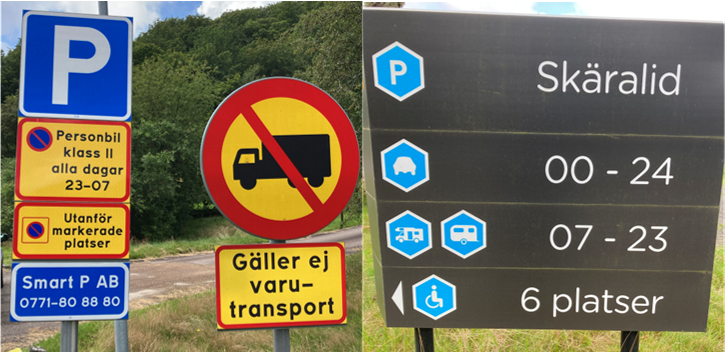
Parking in Skäralid
There are 150 parking spaces for normal-sized cars.
Parking is free of charge. Please follow signage.
The large parking area has the following lay-out.
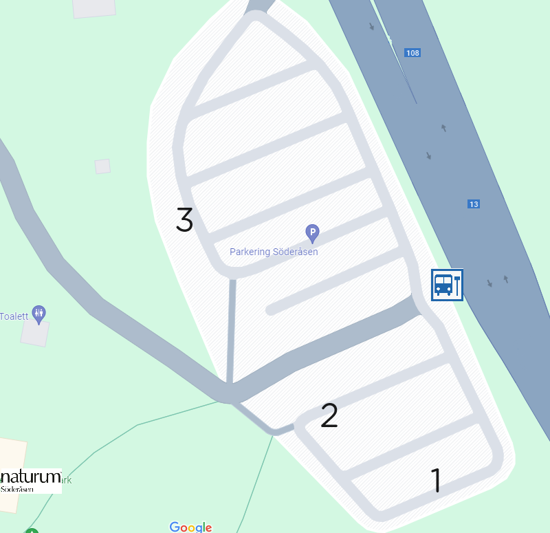
Signage clearly shows how and where you may park with the following clarifications. (see map above)
At number 1 there are two parking spaces for cars with trailers.
At number 2 there are three parking spaces for cars with a permit for the disabled.
At number 3 there are parking spaces for buses/coaches.
By the visitor centre/naturum there are three additional parking spaces for cars with permits for the disabled.
There is no special parking for camper vans. These are to park in regular parking spaces.
There is no room for extra-large/long camper vans/motorhomes, but as an alternative, the first parking row, where there is parking only on one side, can be used.
There are also parking possibilities along the Kopparhatten-road. Follow signage.
Additional permitted parking spaces in the national park, including those along Kopparhatten-road and Serpentin-road can be seen on our hiking trail map.
If there are no available spaces to park at - don't take chances.
You are welcome another day.
Across the road you have Skäralids Camping. Check there if they have available spaces.
Please be considerate with of our neighbours.
Do not block entrances or exits to privat properties.
Camper van/motor home parking is also available in Röstånga.
Share with your friends
Share this page with your friends on Facebook, X (formerly Twitter), Google+ and e-mail.